There are some on Friendlica and Pixelfed but otherwise, you need to get outside the Fediverse to spot them.
ChaoticNeutralCzech
joined 10 months ago
Sure but there is a huge step between not being able to drive the way one wants and where one wants. The cost is also vastly different: human drivers in cars are inherently dangerous and kill 40k people every year in the US. Of course this can be reduced with current technology by incentivizing alternatives to driving.
Microsoft replaced fdisk with diskpart.exe in Windows 2000. I can't imagine how bad the former must have been to warrant that switch. (Or was it super-early enshittification?)
I didn't like the last one. Sure, corpos would love to create a society akin to the one described but the way the story is framed, it's as if driving one's own car is the main tenet of freedom.
I was making a Who Framed Roger Rabbit? joke.
How is this not framed?
Is the president the one in the middle? How is he not the oldest one around?
Edit: the president apparently has power to abolish the Electoral College. So I guess not even attempting to be realistic - at least a non-white-haired president has precedent.
Try integrating with OpenStreetMap Traces and Tapiriik for ease-of-use. Recommend running your own instance for the latter. Not necessarily for the minimum viable product but consider this into the future.
Good bike computers like Garmin's allow GPX export so HW compatibility is there. It's a few manual steps but you can make the process automatic for example by syncing your HW tracker to Tapiriik (15+ brands supported), which then can auto-download GPX files to your computer via Dropbox (or without Dropbox if you run it locally), and then you can auto-upload those to OSM with one of these scripts running on your machine.
The map is a community effort and the lack of social features, which caters to introverts, keeps focus on the end goal - an accurate map of the world. Other platforms are suitable for social activities and you can link to your OSM trace from there.
Yes, seeing the trace geometry only with no map is a letdown. That's why I suggested the visualizer in another comment. It would certainly improve the shareability of traces.
OSM doesn't produce any hardware. They are a wiki-based world mapping effort. In addition, they run a PNG tile provider (so you can embed their map on a website), an article wiki for how to edit the map etc. and the trace repository.
You can use OSM and record traces using various apps mentioned on their wiki.
Come to think of it, OSM traces include timestamps and elevation for each recorded point, plus maybe other data from the uploaded GPX file. Maybe someone will create a Strava-style visualizer that serves HTML, SVGs or PNGs from trace IDs with a map, speed and elevation profile for easy sharing. Imagine your trace is https://www.openstreetmap.org/user/hagu/traces/11959920 and you change openstreetmap.org with perhaps openstreetmap-traceview.org and get a nice sharable overview that also has a PNG for preview on socials. Maybe even a page with a list of activities by user including kilometer stats by month, mode of transport etc.
![White Nio ET5 EV with licence plate "EL0NCLUB" and teslicka\.cz (luxury Tesla rental business) sticker. Pieces of paper under either windshield say: "Elon Musk je nácek. Styďte se!" and B. Mussolini quote "Fascism \[...\] is a merger of state and corporate power."](https://media.witter.cz/media_attachments/files/113/884/852/597/501/847/original/4de7d6727627f338.jpg)
Source (restricted to non-HBO-Max regions)
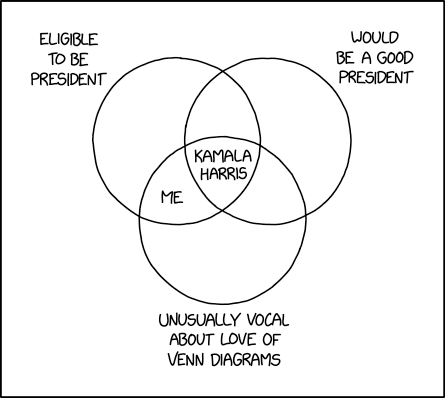
Kamala Harris is known to love Venn diagrams and would be cringing hard at this.
For reference, circles in Venn (Euler) diagrams are sets of objects with a certain property. Select objects are shown inside or outside of each circle depending on whether they belong to the set.
A good example is xkcd 2962:

view more: next ›
Please use the direct URL of the file:
https://i.imgur.com/2SnKSXg.jpeg
